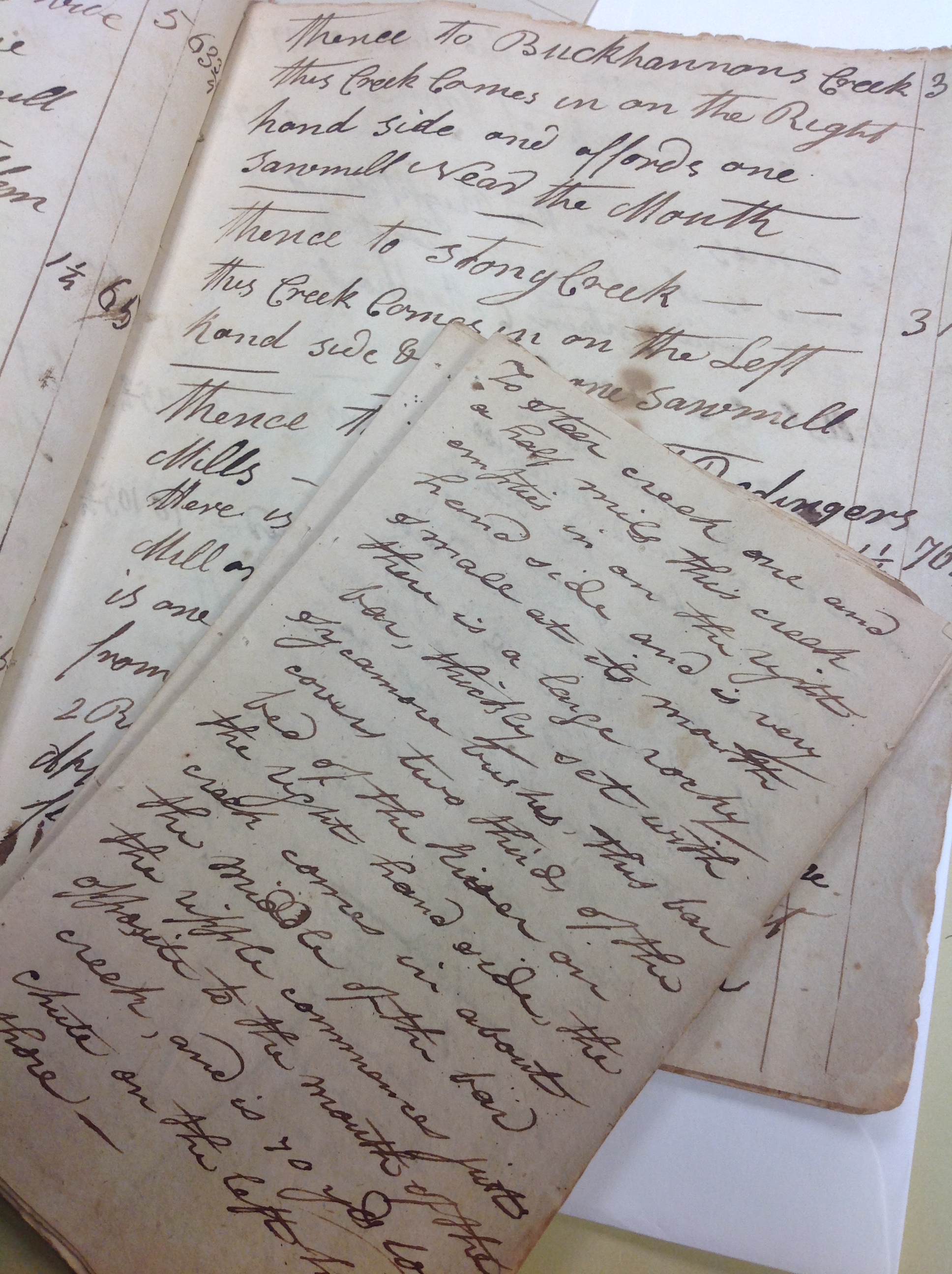
“The Navigator Containing Directions for Navigating Main and South Licking Rivers together with the Distances from one place of Notoriety to another…”
Picture it: 1818, traveling along the Licking River in your flatboat. Unlike the Ohio River, the Licking is more narrow, with many twists, turns, and “ripples” to navigate. Since the Licking is long and splits the state with its course through many counties, a trustworthy guide or map would be your only hope in surviving this type of transport. Then again, you don’t have a lot of room in your small vessel to roll out a map that covers bend by bend details through several counties. What’s a guy to do in this instance? Create your own written guide, detailing your experiences and giving instructions on how to navigate each new bend in the river.
The gentleman who created these booklets of navigation did so in two versions, and roughly in 1818, give or take a year or two. The two booklets are small, well worn after months or years of trips. One book details the navigation instructions for going down the Licking River from the Ohio, and the other gives instructions for heading back from Nicholas County. We cannot say for certain who the author might have been, but there is a clue in a notation concerning the sale of beef. “Octr 3rd 1818 Recd. of Saml Baker six dollars and 84 cents for 171 lb of beef @ 4 cents per lb. The beef for this use of William House. Andrew Porter”

The booklets also contain other notations about potatoes, fish dams, places of trade and warehouses, including a tobacco inspection warehouse outside of Falmouth. Interspersed between the notations about ripples, sandbars, and islands, are many notations about various mills along the way: both flour and saw mills. For the genealogist, this is treasure trove if you suspect your family lived along the river and might have been involved in trade. Many of the mills are identified by the family that owned the mill, plus a detailed description of the buildings that existed on the property at the time: “Thence to Robert Andrews Mills. Here is another first rate merchant mill with a house consisting of 2 story of stone & 2 story of brick 50 feet long by 45 wide with 4 Run of Mill stones with a suitable apparattus for making merchant flour and a good saw mill and a mill dam six feet 8 inches high with 2 slopes…”
What can we speculate about this type of source? Due to the notations and focus on trade, we might be able to suppose that this was an important part of this man’s journey down and up the Licking River. Was it information to bring back to another, or was the information for himself? Was he involved in trade? In the 1850 census, there is an Andrew Porter listed in the Covington area as a “Grocer”. Could this be our Navigator author? We cannot be certain with this little amount of information provided – but it certainly is fun to speculate. Just remember, we have no proof that Andrew Porter is indeed the person who penned these handy little booklets. If the person was involved in trade, he may have been noting proof of a transaction for another merchant, namely, Andrew Porter.

In the mean time, what can we positively learn from this primary source? After analysis from our archivist, we can trust that these booklets were hand written around the time of 1818, based on paper/ink appearance, and a date inside one of the books that reads “September 17th, 1818.” The larger book may be a year or two earlier based on slight differences in his description of the town of Falmouth. In 1818, he describes the town as “containing 75 dwelling houses, two taverns, a post office, one grocery, and five retail stores…” In the larger book, the details are the same, except for a lower number of dwelling houses – 60 instead of 75.
The other wonderful things we can glean from this source, are visual representations of the river during the early part of the 19th century. For the genealogists still reading this far, we can also gather names of those who lived along the river at various points. His information stretches from the Ohio River, down the Licking River, to the mouth of Triplett Creek in Nicholas County. He makes mention of Bourbon, Harrison, Bath, Fleming, Nicholas, and Pendleton Counties. Based on his inclusion of the Ohio River at the mouth of the Licking, along with a description of Decoursey’s Creek, we can include Boone and Kenton Counties in the list of places described within these booklets.
And for the grand finale, here is a list of the surnames found within these booklets: Adams, Andrews, Baker, Bedinger, Blair, Buckhannan (Buchanan?), Fowler, Garrard, Hawking, Hendricks, House, Howard, Jackson, McCarty, Meeks, Morgan, Oldham, Pugh, Porter, Ranking (Rankin?), Stockton, Stockwell.
To view this Collection, simply visit the KHS Library during regular visiting hours and request this item: SC 403
free sample merely need to keep in mind that the that nothing want change.


DeCoursey Creek, DeCoursey Railroad yards along the Licking River, DeCoursey Pike and DeCoursey Baptist church are all named after the William DeCoursey b 1756 MD and came to this area of KY in late 1794+ time frame. Family was in Covington when it was Campbell Co., Alexandria, Cold Spring, California KY for many years until my grandfather Oliver Miles DeCourcy b. 1872 left for IL then MN. DeCoursey can be & is spelled DeCourcy [mostly those living all those years in Campbell Co.,] as the Dr. DeCourcy’s Medical Clinic [my grandfather’s uncles] did in Cincinnati, OH.